
Walk Plain Township Streets by Address
The first pass through a Plain Township street directory should follow the record keys that stay with the land. Use the address to find the parcel, preserve the legal description and tax district, and then decide whether the next question is map context, a recorded instrument, or a dated listing. The Auditor profile names the owner of record and shows tax fields. It is not a statement about every person at the site. A Canton or North Canton postal field also needs a township check before it is treated as Plain Township.
- Open the Stark County Public Access Site and search the street or a full address. Save the parcel ID, owner spelling, legal description, and tax district from the selected profile.
- Open the related parcel in the Stark GIS viewer to see the parcel pattern and the lots that physically touch the street segment.
- For an ownership-history question, search the owner and prior party names through the Recorder, using the legal description to keep similarly named streets apart.
- For an older address clue, ask Stark Library staff for the dated Haines Criss+Cross volume rather than treating a historic listing as current.
- Use Ohio Voter Lookup only after a particular person is already identified. Its name-and-county search is not a street-browsing tool.
That order keeps a street-by-street search tied to sources that actually use addresses. It also leaves a dated trail that can be checked again at the counter when a portal does not return the needed record.
Search Plain Township Street Directory Fields
The Auditor search is the current parcel bridge for a Plain Township street directory. A Street field search can return the matching streets and their property records. Start without a suffix. The official help also documents wildcards at either end, with a trailing wildcard assumed. Address number, direction, city, and ZIP are optional ways to narrow a broad result. Results can be sorted and paged, so a street result may take more than one screen.
| Auditor field | Use for a street search | Verified format |
|---|---|---|
| Parcel ID | Return to one parcel after an address search. | Partial entry is allowed; up to ten characters with no spaces. |
| Owner | Check an owner-of-record spelling found on a profile. | Last name, then first name, without a comma. |
| Address number and Street | Locate a selected site or all matching street names. | Omit the suffix first; wildcard behavior is documented. |
| City and ZIP Code | Narrow a result, with care around postal labels. | Both are optional postal fields. |
When the question shifts from a current parcel record to a historic entry, keep the address and date together. That avoids treating a record from a different period as evidence about the same street today.
Advanced search begins by choosing Residential/Agricultural or Commercial and requires at least one criterion. It can accept comma-separated multiple values after a criteria group is chosen, with no spaces after commas. Those controls help identify property records, not a roster of people along a road.
Note: When a street result is unclear, compare the legal description and tax district before relying on a Canton or North Canton postal rendering.
Read Plain Township Street Parcel Profiles
A parcel profile contains several address-like fields with different purposes. The official Plain Township parcel sample illustrates why the distinction matters. It displays a parcel and routing number, site and postal address, tax mailing name and address, owner, legal description, tax district, land-use context, acres, values, sales and history choices, credits, and links for GIS or aerial mapping. A profile can also show tax-program and inspection fields.
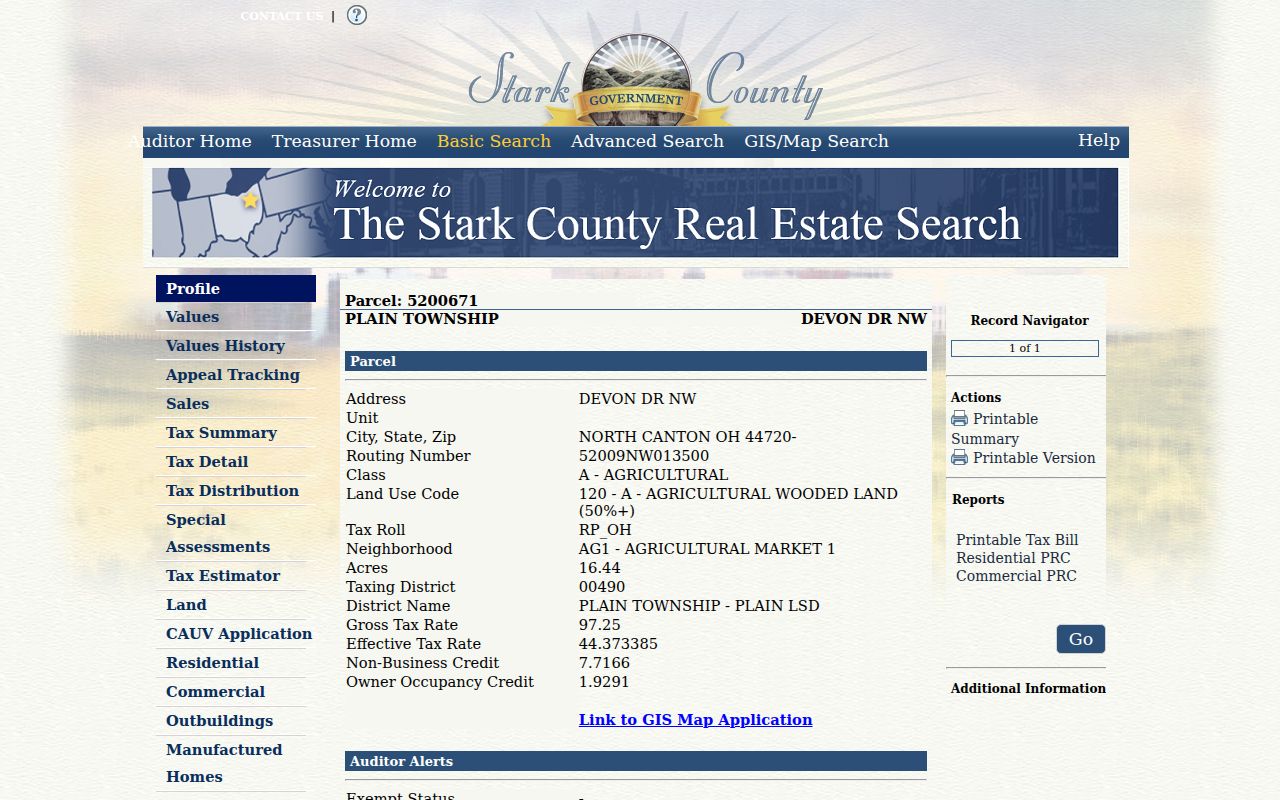
The sample is township-owned rather than a private household. It demonstrates how a Plain Township street directory can use the legal description and district as stable checks while keeping the owner, physical address, and tax mailing address in their separate roles.
| Owner of record | The party shown in the assessment profile. |
|---|---|
| Situs address | The physical or location address assigned to the parcel. |
| Tax mailing address | A delivery field for tax material, which may differ from the parcel location. |
| Legal description | The recorded land description that helps bridge an old address, plat, and current parcel. |
Map Plain Township Street Segments
The county GIS tools extend a Plain Township street directory from one record to the parcel pattern around it. The county’s GIS resources identify Search, Layer List, Select, Identify, Feature Summary, Measure, Print, and other map controls. Search finds an address or map feature. Layer List and map contents turn context layers on or off. Select works by freehand, point, or box, while Identify and Feature Summary inspect the selected feature.
Measure records distance, area, or a point relationship. Print exports the map display. Those tools describe land and mapped features; they do not make a people list. The Auditor ParcelData feature service also states a 2,000-record maximum for a query, another reason to work in a specific street segment instead of attempting a township-wide sweep.
GIS staff can be reached at 330-451-7193, and Tax Map staff at 330-451-7341, when the map needs a custodian-level clarification. Keep the parcel number with any question so the office can locate the same record.
Follow Plain Township Street Deed Links
Use the Recorder after the parcel profile establishes the owner spelling and legal description. The CountyFusion Recorder search quick method calls for the surname followed by the first name, with no punctuation and no changes to the other fields. Select SEARCH at the upper right, then open an Instrument # in the results. The official guide describes name entries from 1982 forward, while Recorder history places the land collection’s beginning in 1809.
- Preserve the parcel ID, legal description, tax district, and current owner-of-record spelling.
- Review Sales or History on the Auditor profile as assessor information, then seek the likely recorded purchase document in the Recorder index.
- Open the Instrument # and note the date and legal description on the document trail.
- Search the prior party in the reverse role, using the legal description to carry the trail across postal or street-format changes.
- For an earlier record or a portal failure, call, visit, or mail the Recorder instead of assuming the record is absent.
The Recorder is at 110 Central Plaza S, Suite 170, Canton, OH 44702-1409, 330-451-7443, on weekdays from 8:30 a.m. to 4:30 p.m. The office describes online recorded-document copies as free. Staff copies are listed at $2 per page, self-service copies at $0.10 per page, and certification at $1 per document. A mail request needs the request, fee, and stamped self-addressed envelope; confirm current copy terms before sending it.
Check Plain Township Address Change Clues
Building material can date a project at a Plain Township address, but it is not a roster. The Stark Building charge search accepts one criterion at a time: permit or invoice number, owner in last-name-first order, project street number and name, or contractor. The county describes this as a charge search, not a complete permit-history archive. A hit is a lead to verify with the Building Department counter, not proof of who was at the address.
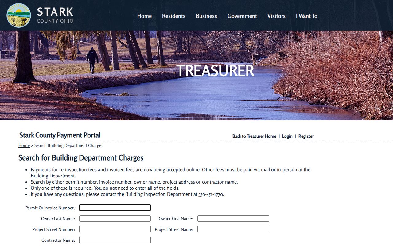
The Building Department covers the unincorporated area and lists its counter at 7235 Whipple Ave NW, Suite A, North Canton, with 330-451-1770 as its phone. Plain Township zoning has no public search index in the reviewed sources. For zoning material, request a defined address, date range, and record category from Township Zoning at 330-492-4686, weekdays 8:00 a.m. to 4:00 p.m. A narrow request under Ohio’s Sunshine Law, R.C. 149.43, is the documented fallback.
Note: A project record can place a change in time, but it should be tested against parcel, deed, directory, and dated map evidence.
Use Plain Township Street Listings by Date
For an older address, the Haines Criss+Cross Directory at Stark Library reverses the usual path. It starts with an address and points to the names or businesses listed in that particular volume. The conventional Canton City Directory works in the other direction, from name toward address. The library confirms the holdings but does not publish an exact run for the Criss+Cross volumes, so ask genealogy or reference staff for the volume closest to the event date.
- Parcel
- A taxed land unit identified by a parcel number and legal description.
- Situs address
- The physical location address for a parcel, distinct from the address used for tax mail.
- Plat
- A recorded map showing a subdivision or lot layout, located through Recorder or Tax Map resources.
- Criss+Cross directory
- A reverse address directory that connects an address to the entries printed for a particular year.
Older listings need a year beside them. The historical directory collections themselves are treated in more depth in the Plain Township city directory reference.
Test Plain Township Street Geography
Plain Township has seven ZIP codes confirmed through tax-district parcel evidence, yet a mailing city on the same set of records can read Canton or North Canton. That is records geography, not a contradiction. The tax district and legal description are stronger evidence that a current parcel belongs in Plain Township than the postal-city field. Use the parcel profile first, then map it in GIS when the boundary question matters.
The caution becomes more important for old documents. Plain Township was one of Stark County’s original 1809 townships, and its original territory later included areas organized into Lake, Lawrence, and Jackson townships. An early township label needs a dated map and legal description before it is assigned to today’s Plain Township. A ZIP or city label alone cannot settle that issue.
Compare Plain Township Street Record Sources
Each source answers a narrower question in a street directory search. Start with the parcel profile for the current land record, use GIS for spatial context, and use the Recorder for the documentary chain. The Building Department and Township Zoning add dated project or permit context when a specific file is requested. The library supplies historic address listings, while the voter tool is limited to a named individual and Stark County selection.
| Address record | What it can show | Access channel |
|---|---|---|
| Auditor parcel profile | Owner of record, site and mailing fields, legal description, tax district, values, and sales choices. | Online Public Access Site, Auditor counter, or 330-451-7357. |
| GIS and tax map | Parcel geometry, selected lots, and mapped context. | Online viewer, GIS staff, or Tax Map staff. |
| Recorded documents | Deeds, mortgages, easements, plats, and the document chain. | CountyFusion, Recorder counter or phone, and Recorder mail request. |
| Building charge clue | Permit or invoice-related project information. | Online charge search and Building Department counter. |
| Township zoning material | Site-plan, permit, or inspection context for a defined request. | Township Zoning phone contact or narrow records request. |
| Historic listing | Address-to-listed entry for a dated directory volume. | Stark Library genealogy or reference assistance. |
Use the next source only for its documented purpose. A parcel number helps connect land records; a dated directory entry helps with historical context; neither changes the limits of the other record.
Set Plain Township Street Directory Limits
A Plain Township street directory can identify property records, documentary parties, and dated directory entries. It cannot establish a current household, utility account, vehicle record, protected voter listing, or every person connected with an address. The Ohio Voter Lookup requires a named individual, first name, last name, and Stark County. It does not offer a road-wide search. Safe at Home participants and other protected-address situations are not gaps to work around.
If the expected record is withheld, contact the original custodian for the permitted route. Do not infer missing personal information from a parcel or try to reconstruct protected address data from separate sources.